
(1868). Taddle Ravine, McCaul's Pond, E, 2024
Foraged Ink Made of Dogwood Berries and Leaves, Sugar Maple Leaves on Photographic Print
70 x 50 cm
We are looking west out on what was once called McCaul’s Pond. A quiet oasis within the University of Toronto campus. The Main building of the University appears ghost-like in the distance just past the trees that ring the pond. McCaul’s Pond was created by damming up the flow of Taddle Creek and as more residential areas grew north of the University the pond began to be a collecting ground for waste. Due to the smell and health concerns, the pond was drained and the creek was turned into a sewer line in 1884. Today we stare at the Student Union building with a curious domed tower. This building was the Toronto Magnetic and Meteorological Observatory until it was no longer practical. In 1907 the building was taken apart and reconstructed on top of McCaul’s Pond. If we were to head north and follow the Philosopher's Walk we would be walking the old creek bed in the still present Taddle Ravine.

(189-). Northwest Branch, Garrison Creek Sewer, 2024
Foraged Ink Made of Norway Spruce Needles, Northern White-Cedar Leaves, Red Maple Flowers, White Oak Leaves on Photographic Print
70 x 50 cm
We are looking north at a team of workers excavating for a sewer. Much of Toronto’s underground construction follows the same basic principles of cut and cover put into place here. These men work in a mobile factory line, those at the front using picks to break hard soil and rock while the ones further back shovel the debris. Even further back bricks and boards are being laid while the men the furthest back stand in long coats and tall hats watching. We know where we are based on the proximity to a road and grade change. In addition this extension of the sewerification to Garrison Creek is mapped and archived to within a few hundred metres. Today we stand in a car park behind a low-rise apartment building. Ahead of us lies a school and its grounds that fill the space between the trees. Below us, from the manhole cover, is the sound of running water.

(1899). After The Breaking Up Of The Don River: Entrance To Rosedale Creek Sewer, 2024
Foraged Ink Made of Bittersweet Nightshade Berries, Zigzag Goldenrod Flowers and Leaves on Photographic Print
70 x 50 cm
We are looking at the west bank of the Waasayishkodenayosh (Don) River after the ice covering it has been shattered. Explosives were used to open up the recently dredged shipping lane. A man poses on a huge piece of ice sitting on a portion of the river bank reinforced against taking a more natural shape. Below is the entrance to the sewer that replaced Rosedale valley’s creek. Above we can see an unobstructed view of the Toronto Necropolis spilling down the hill. Today we are standing on a large stone, part of the abutment for a small railway bridge over the river. This part of track is unused by trains but shows wear from many feet and the paint and messages from many minds.

(1899). East Abutment, Queen Street Bridge Over Don River, 2024
Foraged Ink Made of Common Buckthorn Berries and Leaves, Motherwort Husks, Leaves, and Stems on Photographic Print
70 x 50 cm
We are looking at the fruits of dredging Waasayishkodenayosh the Don River for shipping. Forcing the river into a straight and deep line allowed the building of larger structures like this abutment, brick wall and the sewer emptying into the Don. The silhouette of a man on the other side of the river gives us a sense of scale for the large stones cut to create this footing for a newer steel bridge. Today we find that the Queen Street Viaduct runs far above our heads. The river is no longer used for moving goods and the banks are not kept clear. In its abandonment, fast growing woody bushes have taken over the edge obscuring our view.

(1900). After The Breaking Up Of The Don River, Looking South To Grand Trunk Railway, 2024
Foraged Ink Made of Common Buckthorn Berries, Mugwort Leaves and Stems, Various Grasses, Wild Sumac Leaves on Photographic Print
70 x 50 cm
We are looking at heaping piles of wood and ice floating along the Waasayishkodenayosh (Don) River. Blurred figures work through the debris presumably searching for salvageable parts. It is 1900 and the wooden bridge damaged here by the ice will not be replaced with a steel span for another 30 years. Across the river we can see factories mid construction to take advantage of the Grand Trunk Railway Bridge bringing freight across the river. In the distance the word CURRENCY has been painted onto a sloped roof. Today we see a calm river with tall electrical towers punctuating the sky. The passenger train crosses over a bridge that looks like it could be the replacement for the steel bridge from before but it is a separate construction altogether. We are at the east end of the south Eastern Avenue Bridge. There were two bridges built beside each other, one for a gas line and this one for pedestrians and car traffic. With the construction of the Don Valley Parkway this bridge was deemed not necessary and closed off. There are holes through the edge of the sidewalk and hunks of rust from girders littering the ground. Someone brought concrete mix at one point and built skate ramps. Several others brought spray paint and left their own less permanent marks. The city maintains the bridge as a more cost effective method than demolition.

(1904). Blasting Ice On Don River, 2024
Foraged Ink Made of Common Buckthorn Berries, Common Reed on Photographic Print
70 x 50 cm
We are looking at a plume of dust and ice rocketing up from the surface of the Waasayishkodenayosh (Don) River. It is 1904, 4 years since the wooden bridge at Eastern Avenue was damaged from the ice during winter. Behind the explosives is the Grand Trunk Railway Bridge with a plume of steam rising up indicating a train heading west towards the city centre. Today the water is still, the sky cloudless, the train’s plume invisible to the eye. This close to the water we can see pieces of plastic trash floating slowly down. We are standing on rocks from an abandoned abutment strewn along the side of the river. The graffiti on the bridge in front of us reads XRAY FORTE.

(1906). Looking West From Kew Beach Firehall, 2024
Foraged Ink Made of Bittersweet Nightshade Berries, Black Maple Leaves, White Ash Leaves on Photographic Print
70 x 50 cm
We are looking out from the newly constructed Kew Beach Fire Hall in 1906. There are a few houses dotting Queen Street’s dirt path. It is difficult to tell if in the distance there is smoke, smog, or simply damage to the photo. What can just barely be made out is the reflection of the sky off of Smalls Pond amidst the trees. Here we can see the angle of the creek that would eventually dictate the direction of Kingston Road. Today we are staring into the grey wall of a condominium. The tower we are standing in is used only to hang the hoses and the wooden ladders appear to be original. Just visible above the condo building is the top of the CN Tower standing on what used to be a part of the lake.

(189-). Bain Avenue, 2024
Foraged Ink Made of Common Juniper Berries and Leaves, Siberian Elm Leaves, Silver Maple Leaves, Spreading Cotoneaster Berries and Leaves, White Elm Leaves, White Poplar Leaves on Photographic Print
70 x 50 cm
We are looking west at workers on Bain Avenue finishing the surface of the road. Fumes from the bitumen being spread cloud out the details in the background and leave us focusing on the workers, some of whom pose staring at the camera. We know where we are by the grade of hill on the right side of the frame and the direction of the workers' shadows. Today we can see that just past where they work is the top of the east ridge of the Don Valley. Improvements in road construction have not kept up with the kinds of use our pathways undergo and the road is in a state of repair with a new speed bump where they worked more than 120 years earlier.

(1907). Wychwood Ravine, 2024
Foraged Ink Made of White Oak Leaves, Yew Berries and Leaves on Photographic Print
70 x 50 cm
We are looking east at a man and a boy with a dog gazing at a drying creek bed in Wychwood Ravine. The area shares characteristics with modern day Smalls Creek Ravine which is a deciduous swamp and would count it among the 85% of wetland that has been lost in the Toronto area. The man stands with his hands on his hips staring at the water. It is not clear if he is passing judgement on a pierced lack of utility in this intermittent creek, considering how best to step across to the path on the other bank, or just looking at something in the reflection. Today we are barred by a ROAD CLOSED sign as we stand on Lowther Avenue. If we continue east we will come across Taddle Creek playground with Ilan Sandler’s Vessel, a fountain made in the shape of a pitcher from 4 kilometres of steel rod, the artist's approximate length of Taddle Creek. That spot marks the most likely place the creek would have bent southward towards the lake.

(1912). Swimming In The Don River, 2024
Foraged Ink Made of Common Thistle on Photographic Print
70 x 50 cm
We are looking north east at children aligned at the bank of the Waasayishkodenayosh (Don) River. Two figures in the river appear as though they are demonstrating something. The north edge of the river is a soft cliff-face with holes scooped out potentially by kids making hand holds. The river is an easy standing height and the south side is a sandy beach. In the distance the feet of the Bloor Viaduct are visible. Today this is a difficult place to reach, Bayview Avenue and two sets of active rail tracks cut off access to the river from the west; the Don Valley Parkway and a rail track cut access from the east. The Lower Don trail is inaccessible due to construction. The sand has mostly washed from the shore, shrubs and fast growing trees crowd the horizon so that the Viaduct is just barely visible behind. The 2013 Lower Don Trail Master Plan says,
“Not every city has a vast landscape of forests, fields and marshes within walking distance of its downtown core. The Lower Don Valley is one of Toronto’s largest, most centrally located—but perhaps also most under appreciated—urban open spaces.” (City of Toronto, 2023, p. 3)

(1912). Crawford Street Bridge, 2024
Foraged Ink Made of Norway Spruce Needles, Northern White-Cedar Leaves, Red Maple Flowers, White Oak Leaves on Photographic Print
70 x 50 cm
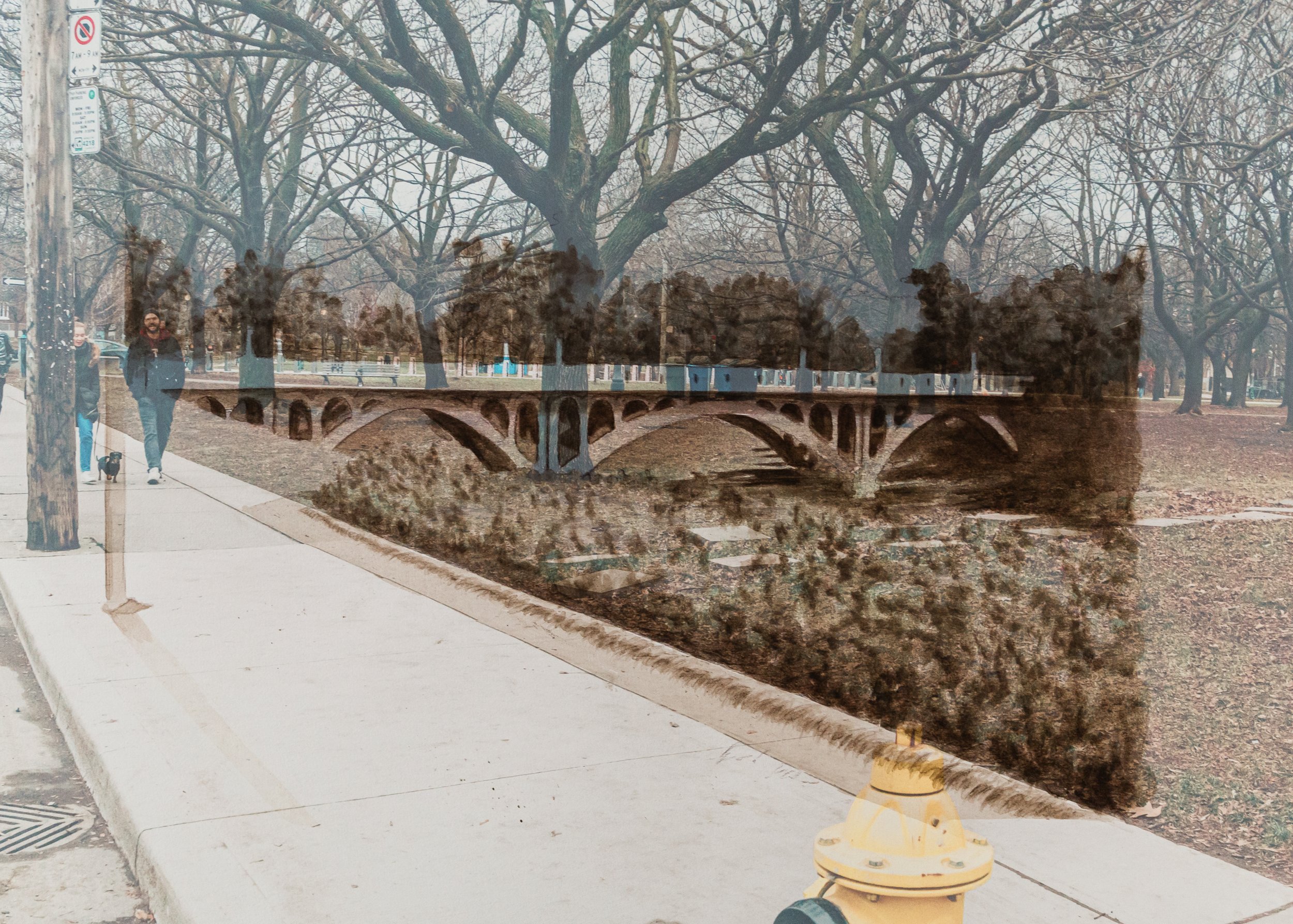
We are looking southwest at the original Crawford Street Bridge. This wooden bridge ‘fords’ the ravine carved by Garrison creek, so named because its mouth formed the location for Fort York to be built. Wear-marks on the grass show signs of where students from Trinity College might have gone for leisure though by this time the college was already in the process of transferring to a new downtown location. Today we watch a car drive across what is clearly not a bridge flanked by city and personal bikes on either side. We are standing on the south side of Dundas street between three 12 feet tall pipes designed to discreetly release odours from the Mid-Toronto Interceptor Sewer (Blackett, 2010).

(1914). Bellwoods Park, 2024
Foraged Ink Made of Norway Spruce Needles, Northern White-Cedar Leaves, Red Maple Flowers, White Oak Leaves on Photographic Print
70 x 50 cm
We are looking west out over the edge of the Crawford street bridge as people toboggan down the ravines' snowy slopes. The inscription reads “FEB 14 1914 Bellwoods Park” which makes it Valentine’s Day. The park got the name “Bellwoods” potentially from its relationship to Alderman William Bell elected to St. Stephen’s Ward in 1888 (City of Toronto Archives, n.d.-b). At the time the Toronto colony was divided into wards named for Christian saints. St. Stephen’s ward (the ‘protomartyr’ of Christianity) was bounded by Queen Street, Bathurst, Dufferin and Bloor (City of Toronto Archives, n.d.-a). Between 1880 and 1889 the road along the east side of the park changed names from Strachaun to Bellwoods (Toronto Public Library, Library and Archives Canada, and City of Toronto Archives, n.d.). Today we will not see kids sliding down the hill though far to the north a similar sight can be held in Christie Pits park which happens to be a ravine caused by the same Garrison Creek. We will still see couples holding hands.

(1914). Construction Of Crawford Street Bridge, 2024
Foraged Ink Made of Norway Spruce Needles, Northern White-Cedar Leaves, Red Maple Flowers, White Oak Leaves on Photographic Print
70 x 50 cm
We are looking at the Crawford Street Bridge undergoing a transition from timber construction to steel and concrete. Steel reinforcement beams have been laid in arches with wooden forms supporting underneath to act as moulds for the eventual concrete pour. From this perspective we can see along the ravine and watch fog flow down over the edge to pool in the basin. Today we look straight into a sign which reads “RIDE TO WORK RIDE TO TRANSIT” a part of the city bike charging and locking station. The ground is notably level as opposed to a deep wide ravine. The dirt here was excavated in the construction of the Bloor subway line in the 1960s. At the other end of this part of the park hidden just behind the tree there is a plaque which reads “Crawford Street passes through Trinity Bellwoods Park over a graceful triple-span concrete bridge which still exists, but is now buried beneath the street.”

(1916). Wychwood Park - General Creek Scene, 2024
Foraged Ink Made of American Beech Leaves, Amur Maple Leaves, Red Currant Berries and Leaves on Photographic Print
70 x 50 cm
We are looking north at a section of Taddle Creek reaching into Wychwood Park. This residential enclave, located near the intersection of Bathurst Street and St. Clair Avenue, was established in the late 19th century by landscape architect and painter Marmaduke Matthews. He envisioned a neighbourhood that would foster creativity and provide a peaceful sanctuary for artists seeking inspiration. This community centred on a natural spring which fed Taddle Creek and potentially Garrison Creek. Today we are on a median in the middle of Dupont Road staring at a fence. This marks the southern boundary of one Wychwood property, one of the most expensive real estate areas in the city. By creating an exclusive site of only 60 lots, preserved through the heritage site designation, Wychwood park fed into capitalist mechanisms of supply and demand. The neighbourhood is gated at this end and the spring has been dammed which allows for a natural skating rink in the winter and two swans a place in the summer. At the time of writing 17 Wychwood Park is for sale with an asking price of $7,950,000.00.
(1917). Crawford Street Bridge, 2024
Foraged Ink Made of Norway Spruce Needles, Northern White-Cedar Leaves, Red Maple Flowers, White Oak Leaves on Photographic Print
70 x 50 cm
We look over a manicured flower bed out onto the finished Crawford Street Bridge. If it evokes a miniature Bloor Viaduct that is no mistake, both were projects of Roland Caldwell Harris the longtime public works commissioner for the city. This bridge began construction just 2 years after Harris was hired. The creek that made this ravine would continue to flow for another 3 years before being entirely diverted into the underground sewer system. Today thick trees evenly fill out the space occasionally used as a farmers market. If the tree coverage were any more sparse we would look directly towards the CN Tower.

(1919). Small's Pond Bridge, 2024
Foraged Ink Made of Black Maple Leaves, White Ash Leaves on Photographic Print
70 x 50 cm
We are looking north at a bridge over the east branch of Smalls Creek entering Smalls pond. It is late April and the southern end of the bridge appears damaged potentially from the winter. The boards wave, warp, and several are missing. Across the creek houses nestle around a road, backyards and fences drooping to meet the creek. We find this place a quiet road leading to low rise apartment buildings and small homes. There are signs cautioning construction and indicating an entrance for trucks onto the lot of a building. If you look carefully you will see this lot drops down to meet the original grade of the creek but no other traces remain.
It is now the end of Edgewood Ave.

(1920). Small's Pond Looking North To Ashland Avenue, 2024
Foraged Ink Made of Bittersweet Nightshade Berries, Field Larkspur Flowers, Northern Pin Oak Leaves, Silver Maple Leaves, Spreading Cotoneaster Berries and Leaves, Tulip Tree Leaves, Yellowwood Leaves and Seed Pods on Photographic Print
70 x 50 cm
We are looking north at Small’s Pond. This area was the slow moving confluence of two branches of Smalls Creek. Houses creep up to the edge of a sunken y-shaped basin filled to perhaps 10 feet below its brim. It is late April and there are no leaves on the trees reaching their branches into the frame from the right. The sky is clear to the point that a faint marbled wave is visible from some disturbance in the printing process. We find this place with leaf strewn level ground. If we could see around the trees still to the right we would see a children’s park with a metal sculpture of a reed acting as a water element in the summer. The area was affected by the pollution of Ashbridge’s Bay and disturbance of the water table elsewhere. Smalls creek flowed into the bay and became polluted with waste from the homes to the north and industry to the sound.
Foraged Artworks